Old Ordnance Survey Maps of London

  • These detailed maps maps normally cover an area of about one and a half miles by one mile. Each map includes an introduction. The London maps link up with those for Middlesex to form a major series for the Greater London area. They are available through our On-line Mapshop

  • Here are the details of maps for Bromley Common:

  • London Sheet 156 Bromley Common & NE Hayes 1895 - published 2013; intro by Pamela Taylor. ISBN.978-1-84784-731-7

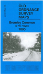
    This detailed map covers the Bromley Common area south of Bromley. Coverage stretches from Walpole Road southward to St Mary's church, Hayes.

    Features include Trinity church, Barham House, Cooper's Farm, Turpington Farm, The Rookery, Hook Farm, Oakley House,St Mary's church Hayes, Hayes Place. Extracts from a 1905 directory of Kent are included on the reverse.

    The map links up with London sheets 153 Bromley S to the north.


  • Follow this link for a complete list of our London maps .
  • You can order maps direct from our On-line Mapshop. For other information and prices, and other areas, go to The Index Page.
  • Maps in the Godfrey Edition are taken from the 25 inch to the mile map and reduced to about 15 inches to the mile. For a full list of maps for England, return to the England page.
    Alan Godfrey Maps, Prospect Business Park, Leadgate, Consett, Co Durham, DH8 7PW / sales@alangodfreymaps.co.uk / 21 February 2018