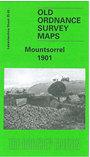
Leicestershire Sheet 25.02 Mountsorrel 1901 - published 2004; intro by John Gough. ISBN.978-1-84151-682-0 
This detailed map covers the village of Mountsorrel, with coverage stretching along the main road from Bond Lane southward to Union Lane.
Features include Castle Hill, South End area, St Peter's church, Barrow upon Soar Workhouse, The Green, River Soar, Mountsorrel Quarries, Broad Hill, Nunckley Hill Quarries, Hawcliff Quarry, Mountsorrel Railway serving the quarries, etc. On the reverse we include an 1891 directory of Mountsorrel
Follow this link for a list of our Leicestershire maps or here for Leicester itself.
You can order maps direct from our On-line Mapshop.
For other information and prices, and other areas, go to The Index Page.
Maps in the Godfrey Edition are taken from the 25 inch to the mile map and reduced to about 15 inches to the mile.
For a full list of maps for England, return to the England page.
The Godfrey Edition / sales@alangodfreymaps.co.uk / 6 October 2016

 Here are the details of maps for Mountsorrel: