Old Ordnance Survey Maps of Leicestershire

  • These detailed maps normally cover an area of about one and a half miles by one mile. Each map includes an introduction.
  • They are available through our On-line Mapshop

  • Here are the details of maps for Coalville:

  • Leicestershire Sheet 23.04 Coalville 1901 - published 2001; intro by Steph Mastoris. ISBN.978-1-84151-349-2

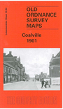
    This detailed map covers much of the small industrial town of Coalville. Coverage stretches from Gutteridge Street eastward to Broom Leys and Constable Lane.

    Features include Midland Railway with Coalville station, LNWR Charnwood Forest Branch with station, Whitwick Colliery and Whitwick Colliery Railway, Railway Wagon Works, Elastic Web Factory, iron works, cattle market, The Park, Christ Church, part of Snibston Colliery Railway, Colliery Farm, brick and terra cotta works, Glebe Farm, Broom Leys, Whitwickwaste Farm etc. On the reverse we include an 1891 directory of Coalville, plus an extract from a 1916 timetable for the Leicester-Burton line.


  • Follow this link for a list of our Leicestershire maps or here for Leicester itself.
  • You can order maps direct from our On-line Mapshop. For other information and prices, and other areas, go to The Index Page.
  • Maps in the Godfrey Edition are taken from the 25 inch to the mile map and reduced to about 15 inches to the mile. For a full list of maps for England, return to the England page.
    The Godfrey Edition / sales@alangodfreymaps.co.uk / 6 October 2016