
 Here are the details of maps for Kennington & Walworth:

We have published three versions of this map, showing how the area developed across the years. The maps each cover the same busy area, stretching from the east side of Vauxhall Bridge eastward to Walworth Road and a little beyond; and from the south end of Elephant & Castle station southward to Cranmer Road and Addington Square. Walworth Road and Kennington Park Road run north-south through the map, whose many features include the Oval cricket ground, Vauxhall and Walworth Road stations, tramways, Kennington Park, Vauxhall Park, London Pottery, Lambeth Pottery, the end of the Surrey Canal, Surrey Gardens, Lambeth Workhouse, many churches and innumerable streets. The 1871 map has street directories for Kennington Oval, Princes Road, Upper Kennington Lane and Walworth Road, and the other maps have further extracts.
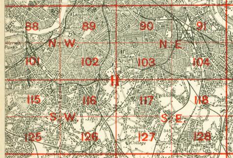
The map links up with London Sheets 76 Waterloo to the north, 88 Pimlico to the west, 90 Old Kent Road to the east, and 102 Camberwell to the south.
 Follow this link for a complete list of our London maps .