
Old Ordnance Survey Maps of Harrow
We have good coverage for the London Borough of Harrow. This was formed in 1965 from the Municipal Borough of Harrow, which followed the creation of Harrow
Urban District in 1934, through a merger of Harrow-on-the-Hill UDC and Wealdstone UDC, together with part of Hendon Rural District.
All maps are available from our On-line Mapshop.
The following titles are all taken from the OS 25" maps and reduced to a scale of approximately 14 inches to the mile.
They are extremely detailed, showing individual houses, details such as railway tracks, pathways,
pubs, factories and even minutiae such as fountains and signal posts. Each covers an area of a mile and a half by one mile, and includes an introduction.
 These are the principal maps for the London Borough of Harrow in our Middlesex series:
05.15 Harrow Weald & Hatch End 1935 - published 2009; intro by Pamela Taylor
05.16 Great Stanmore 1935 - published 2008; intro by Pamela Taylor
10.02 Pinner (North) 1935 - published 2009; intro by Pamela Taylor
10.03 Wealdstone & Hatch End 1935 - published 2009; intro by Pamela Taylor
10.06 Pinner (South) 1940 - published 2009; intro by Pamela Taylor
10.07 North Harrow & Headstone 1935 - published 2009; intro by Pamela Taylor
10.08a Kenton & Wealdstone 1912 - published 2002; intro by Pamela Taylor
10.08b Kenton & Wealdstone 1936 - published 2012; intro by Alan Godfrey
10.10 Rayners Lane & Eastcote 1939 - published 2008; intro by Alan Godfrey
10.11a Harrow-on-the-Hill 1912 - published 2017; intro by Pamela Taylor
10.11b Harrow-on-the-Hill 1935 - published 2007; intro by Alan Godfrey
10.12 South Kenton & Northwick Park 1936 - published 2011; intro by Pamela Taylor
10.15 South Harrow & Northolt Park 1935 - published 2009; intro by Alan Godfrey
10.16 Sudbury 1936 - published 2008; intro by Alan Godfrey
11.09 Preston Road 1940 - published 2011; intro by Pamela Taylor
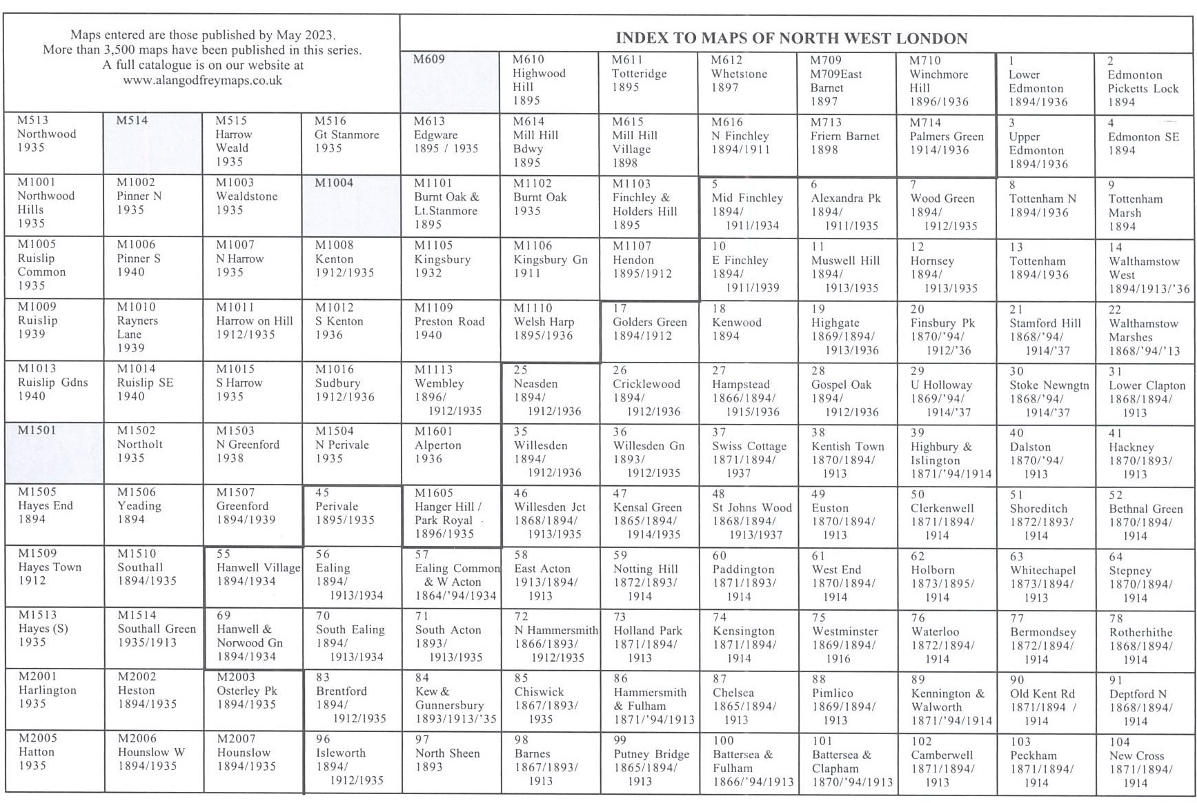
Here is an index map for The North West London maps.
Each map has a specially written introduction. As a sample, that for the Harrow-on-the-hill 1935 map is available online.
 Most maps in the Godfrey Edition are taken from the 25 inch to the mile map and reduced to about 15 inches to the mile.
For a full list of English maps, return to the England page
You can order maps direct from our On-line Mapshop.
Most maps in the Godfrey Edition are taken from the 25 inch to the mile map and reduced to about 15 inches to the mile.
For a full list of English maps, return to the England page
You can order maps direct from our On-line Mapshop.
Alan Godfrey Maps, Prospect Business Park, Leadgate, Consett, DH8 7PW. Tel 01207 583388
The Godfrey Edition / sales@alangodfreymaps.co.uk / 22 February 2018