Old Ordnance Survey Maps of Penarth


We have published more than 2,200 maps in our series of Old Ordnance Survey Map reprints, and have now started work on a group for Glamorgan. Others will follow! The maps are highly detailed. They are taken from the OS 1:2,500 (or 25 inch) maps and reduced to about 15 inches to the mile. Each covers an area of a mile and a half by a mile. They show streets with individual houses, tram tracks, railway tracks and even signals, factories, wharves and such details as fountains and water troughs. They will provide hours of fascination for historians and genealogists. The maps are neatly folded and each includes a specially written introduction to the area. Maps can be purchased on our On-line Mapshop where further information about titles is given. Or visit The Index Page for a full list to the series and details of Prices.


  • Here are the details of maps for Penarth:

  • Glamorgan Sheet 47.11 Penarth Town 1915 - published 2008; introduction by Derrick Pratt

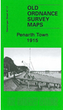
    This very detailed map covers the town and seaside resort of Penarth, a few miles south of Cardiff. Coverage stretches from Albert Crescent and Penarth Head southward to Augusta Road, and from the shoreline westward to Morristown and Redlands Road. Features include railway with station, Dingle Road Halt, Alberta Place Halt, Alexandra Park, pier, All Saints church, St Joseph's RC church, Penarth House, Paget Rooms etc. On the reverse we include extracts from a list of private residents, entries A-L.

    The map links up with sheet 47.07 Penarth Dock to the north.


    Follow this link for a complete list of our Glamorgan maps.

    You can order maps direct from our On-line Mapshop. For other information and prices, and other areas, go to The Index Page.


    Maps in the Godfrey Edition are taken from the 25 inch to the mile map and reduced to about 15 inches to the mile. For a full list of maps for Wales, return to the Wales page.

    The Godfrey Edition / godfreyedition@btinternet.com / 25 March 2009