
 Here are the details of maps for Eltham Green:

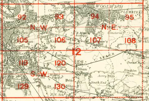
We have published three versions of this map, showing how the area developed across the years. The actual London maps each cover much the same area, stretching from Leyland Road at Lewisham eastward to Eltham Green and a little beyond, and northward to Kidbrooke station. This is an area with several streets being developed on the west side of the map, where the map fringes Blackheath Park and Lewisham; also near St Peter's church on The Avenue. The area around Eltham Green is largely rural.
We have extended coverage of the 1894 version by including part of Kent Sheet 8.01 on the reverse. This takes coverage to the centre of Eltham village, with St John's church, Court Yard, Eltham Court and the remains of Eltham Palace, and also Well Hall station. Therefore, if you are buying only one of the maps I strongly advise the 1894 version.
The map links up with London Sheets 106 Kidbrooke to the north, 119 Lewisham to the west, and 130 Mottingham to the south.
 Follow this link for a complete list of our London maps .