
 Here are the details of maps for Barking & East Ham:

We have published three versions of this map, showing how the area developed across the years. The maps each cover the same area, stretching from High Street North at East Ham eastward to Barking station; and from Jersey Road and Manor Park Athletic Grounds southward to Caulfield Road.
The River Roding runs north-south through the centre of the map, East Ham to one side, Barking to the other. Features include East Ham and Barking stations, Linton Road, East Street, Uphall chemical works, various works beside the Roding, railway junctions, housing development at East Ham. The 1894 version also includes a large extract of Essex sheet 73.12 to the south, showing more of Barking incl St Margaret's church, White Gate Bridge, also of East Ham incl Wallend. If you are only buying one map we therefore recommend the 1894 version.
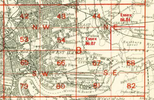
The map links up with London Sheets 34 Ilford to the north, 43 Forest Gate to the west, and Essex Sheets 86.04 Upney to the east and 86.07 East Ham & Barking South to the south.
 Follow this link for a complete list of our London maps .