Old Ordnance Survey Maps of Deptford


We have published more than 1,800 maps in our series of Old Ordnance Survey Map reprints, some 300 of them in the London area. The maps are highly detailed. They are taken from the OS 1:2,500 (or 25 inch) maps and reduced to about 15 inches to the mile. They show streets with individual houses, tram tracks, railway tracks and even signals, factories, wharves and such details as fountains and water troughs. They will provide hours of fascination for historians and genealogists. Wherever possible we publish the London maps in 2 or 3 versions, so you see how the area developed across the years. The maps are neatly folded and each includes a specially written introduction to the area. Maps can be purchased on our On-line Mapshop where further information about titles is given.


Here are the details of maps for Deptford:

  • London Sheet 91.1 Deptford (North) 1868 - published 2004; introduction by Alan Godfrey
  • London Sheet 91.2 Deptford (North) 1894 - published 2002; intro by Alan A Jackson
  • London Sheet 91.3 Deptford (North) 1914 - published 1985; intro by Richard Martin

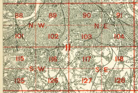
    The three versions of this map show how the area developed across the years, becoming more built up. The maps each cover the same area, stretching from Canterbury Rd and Ormside Street eastward to Deptford Green; from Rotherhithe Road and Deptford Wharf southward to St Paul's church. Features (which obviously change with the passing of time) include the Royal Dockyard and Royal Victoria Victualling Yard, shown in detail on the earliest map; the northern part of Deptford High St; Evelyn Street; the Grand Surrey Canal; Coldblow Farm; the Thames Junction Branch railway; St Helena Gardens; numerous railway lines; The Den, Millwall FC; Southwark Park station Foreign Cattle Market; a small section of West Ferry Road on the north bank of river, various tramways. Churches include St Paul's Deptford. Roads on the 1868 map include Evelyn St, Plough Road, Edward St, Old King St, Rotherhithe New Rd, White Post Lane, Chilton St, part of Deptford High St. Many other roads appear on the later maps as they are built. The map links up with Sheet 104 New Cross to the south, which covers Deptford Broadway and New Cross, and Sheet 92 Greenwich to the east.

    An index map showing the areas covered by this and adjacent maps is available here. The map links up with Sheets78 Rotherhithe to the north, 90 Old Kent Road to the west, 92 Greenwich to the east, 104 New Cross to the south.

    Follow this link for a complete list of our London maps


    The maps cost just £2.20 each. You can now order maps direct from our On-line Mapshop. For other information and postage costs, see Index Page and Ordering Information Page.


    Maps in the Godfrey Edition are taken from the 25 inch to the mile map and reduced to about 15 inches to the mile. For a full list of maps for London, return to the London page

    The Godfrey Edition / godfreyedition@btinternet.com / 24 July 2005