
 Here are the details of maps for Clapham Common:

We have published three versions of this map, showing how the area developed across the years. The maps each cover the same area, stretching from Grandison Road and Wroughton Road eastward to Bedford Road and Lyham Road; and from Freke Road and Clapham High St southward to Malwood Road.
Almost all of Clapham Commnon itself is on the map while to the NE of it are the closely packed streets of Clapham, with much of the High St, Holy Trinity church, Park Crescent, Polygon, St Peter's church. However, there are great contrasts between the two maps elsewhere: on the 1870 map the area east and SE of the Common, including much of Clapham Park, is filled with villas in leafy grounds; by 1894 many of these were being replaced by terraces and semis in streets such as Narbonne Avenue, Abbeyville Road, Elms Road etc. But some large houses survive, such as Cavendish House, from which the eccentric scientist Henry Cavendish weighed the world in 1798; this estate would be sold for development in 1905. The essays by Keith Bailey explain these changes. Each map includes extracts from a contemporary directory.
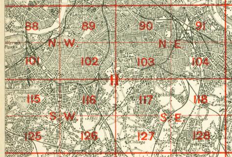
The map links up with London Sheets 101 Battersea & Clapham to the north, 115 Wandsworth to the west, 116 Brixton to the east, 125 Clapham Park to the south.
 Follow this link for a complete list of our London maps .