
 Here are the details of maps for Charlton:

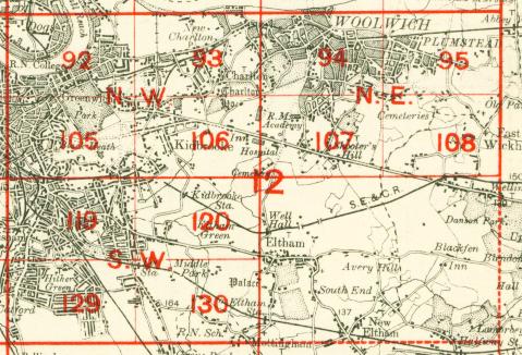
The three versions of this map show how the area developed across the years, becoming more built up. The maps each cover the same area, stretching from Beaconsfield Rd and Westcombe Park station eastward to Mount Street and Maryon Park; from New Charlton and Anchor Hope Lane southward to Charlton House. Features include Charlton House; Westcombe Park and Charlton stations; Woolwich Road with its tramways; the Angerstein Wharf railway branch; numerous old sand pits; Charlton Village; much of the Westcombe Park estate including Mycenae Road and Woodlands. The 1867 map also includes a tramway into the sandpits (near what is now Charlton FC) and has an extract of the map southward to Shooters Hill Rd. Each map also includes extracts from early directories listing some of the people who lived here. A small portion of Woolwich, around Sand St, is also included. Churches include St Luke's Charlton, St Paul's Fairfield Road, St George's Glenluce Road, Holy Trinity Woolwich Road, St Thomas Woodland Terrace. Roads on the 1867 map include Greenwich and Woolwich Lower Road, Sand Street, Lansdowne Road, Church Lane, Charlton Road, Combe Farm Lane, Victoria Road. Many other roads appear on the later maps as they are built.
The map links up with Sheets 80 Silvertown to the north, 92 Greenwich to the west, 94 Woolwich to the east and 106 Kidbrooke to the south.
 Follow this link for a complete list of our London maps .