We have published more than 1,800 maps in our series of Old Ordnance Survey Map reprints, including a group in Buckinghamshire. The maps are highly detailed. They are taken from the OS 1:2,500 (or 25 inch) maps and reduced to about 15 inches to the mile. Each covers an area of a mile and a half by a mile. They show streets with individual houses, tram tracks, railway tracks and even signals, factories, wharves and such details as fountains and water troughs. They will provide hours of fascination for historians and genealogists. The maps are neatly folded and each includes a specially written introduction to the area. Maps can be purchased on our On-line Mapshop where further information about titles is given. Or visit The Index Page for a full list to the series and details of Prices.
Here are the details of maps for Bletchley:
This detailed map covers an area that is now the southern part of Milton Keynes. The map is double-sided to give maximum coverage. The main map covers Fenny Stratford, and features include Fenny Stratford station, St Martin's church, the Grand Junction Canal, Aylesbury Street, the site of Magiovintum, the northern part of Bletchley station and railway sidings. On the reverse is part of sheet 15.14 extending coverage south to the centre of Bletchley, the rest of the station, and coverage extends east to Water Eaton. A short directory to Fenny Stratford and Bletchley is also included.
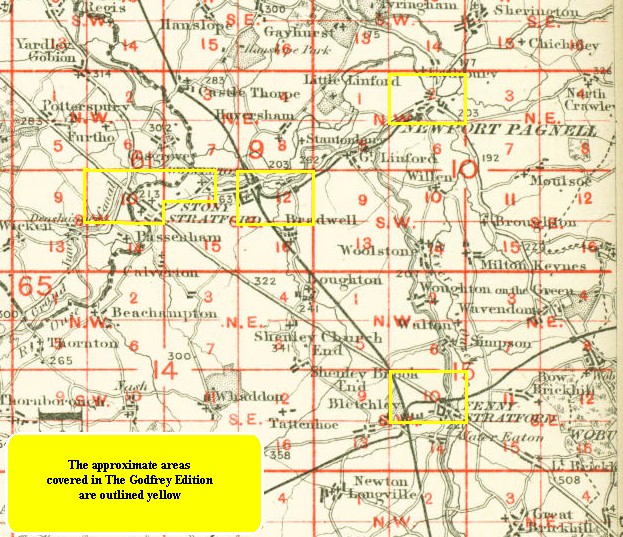
You might find this index map useful.
Follow this link for a complete list of our Buckinghamshire Series maps.
You can order maps direct from our On-line Mapshop. For other information and prices, and other areas, go to The Index Page.
Maps in the Godfrey Edition are taken from the 25 inch to the mile map and reduced to about 15 inches to the mile. For a full list of maps for the Buckinghamshire area, return to the Thames & Chilterns page
The Godfrey Edition / godfreyedition@btinternet.com / 11 November 2005