
 Here are the details of maps for Beckton:

Until the 1840s Beckton was "a marshy waste, a notorious venue for illegal prize-fighting" writes author Stephen Pewsey, and these maps still show an area with few inhabitants. The principal feature of these maps is the vast Gas Works of the Gas Light & Coke Company, shown here with all its many railway sidings, and adjacent to a large Tar & Liquor Works. The Northern Outfall Sewer runs across the map, as does the GER Beckton Branch, with its Beckton station. Other features include the group of streets known as Cyprus, a section of the Royal Albert Docks Railway, St Michael & All Angels church, and the group of houses known as Roman Road. The 1894 map also includes a section of Essex Sheet 73.16, which takes coverage northward across the marshes, up High Street South, Gooseley Lane and Claps Gate Lane. The 1914 map includes a 1915 GER Timetable for the Liverpool Street to North Woolwich line, including the occasional trains to Beckton.
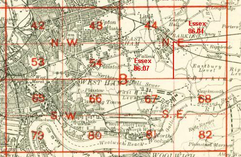
The map links up with London Sheets 66 Canning Town to the west, 68 Creekmouth to the east, 81 North Woolwich to the south; and with Essex sheet 86.07 East Ham & Barking South to the north.
 Follow this link for a complete list of our London maps .