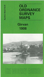
Ayrshire Sheet 55.04 Girvan 1908 - published 2000; intro by John Griffiths. ISBN.978-1-84151-144-3 
This detailed map covers most of the Ayrshire town of Girvan. Features include the Harbour, railway with station, Goods & Harbour Branch,
Newton Kennedy, The Green, church, South Church, Church Square, Bridge Mill, Trowier Mote, infectious diseases hospital, Houdston Hill,
Knowehead. On the reverse we include a large section of the earlier 1894 map for comparison, and this extends coverage a little further south to Dounepark.
Follow this link for a complete list of our Ayrshire maps.
You can order maps direct from our On-line Mapshop.
For other information and prices, and other areas, go to The Index Page.
Maps in the Godfrey Edition are taken from the 25 inch to the mile map and reduced to about 15 inches to the mile.
For a full list of maps for Scotland, return to the Scotland page.
The Godfrey Edition / sales@alangodfreymaps.co.uk / 15 November 2016
 Here are the details of maps for Girvan: