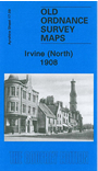
Ayrshire Sheet 17.09 Irvine (North) 1908 - published 2009; intro by Gilbert Bell. ISBN.978-1-84784-217-6 
This detailed map covers the northern half of Irvine, with coverage stretching from the High Street and Bank Street northward to Ravenspark, and eastward to Stanecastle.
Features include Duntonknoll Quarry, Thornhouse Soap & Candle Works, parts of Cadgers Race Course, Seagate Castle, Academy, Burns Street, Caledonian Forge, Lanarkshire & Ayrshire Railway branch with terminus,
Ballot Road etc.
Follow this link for a complete list of our Ayrshire maps.
You can order maps direct from our On-line Mapshop.
For other information and prices, and other areas, go to The Index Page.
Maps in the Godfrey Edition are taken from the 25 inch to the mile map and reduced to about 15 inches to the mile.
For a full list of maps for Scotland, return to the Scotland page.
The Godfrey Edition / sales@alangodfreymaps.co.uk / 15 November 2016
 Here are the details of maps for Irvine (North):