Old Ordnance Survey Maps of Argyll & Bute
We have published just a few maps for Argyllshire and Buteshire. Each includes an introduction.
They are available through our On-line Mapshop
Argyllshire and Buteshire were two of Scotland's historic counties. Both were abolished in 1975 when they became part of Strathclyde Region. The Isle of
Arran was transferred from Buteshire to Ayr.
Strathclyde region was abolished in 1996 and Argyll & Bute became a unitary council.
See This Page for more information on the area's local government history.
 These are our maps for Argyllshire:
098.07 Oban 1898 - published 2008; intro by Gilbert Bell
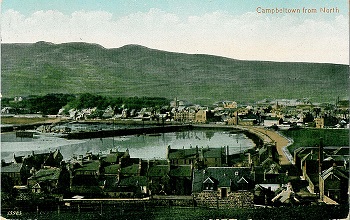
257.08 Campbeltown 1898 - published 2006; intro by Gilbert Bell
These are our maps for Buteshire:
Sheet 204.06 Rothesay 1896 - published 2009, intro by Gilbert Bell
 Most maps in the Godfrey Edition are taken from the 25 inch to the mile map and reduced to about 15 inches to the mile.
For a full list of maps for Scotland, return to the Scotland page
You can order maps direct from our On-line Mapshop.
This list shows all our maps for the area. We try to keep a full range in print but inevitably some titles fall out of print from time to time.
These are noted in our On-line Mapshop.
Most maps in the Godfrey Edition are taken from the 25 inch to the mile map and reduced to about 15 inches to the mile.
For a full list of maps for Scotland, return to the Scotland page
You can order maps direct from our On-line Mapshop.
This list shows all our maps for the area. We try to keep a full range in print but inevitably some titles fall out of print from time to time.
These are noted in our On-line Mapshop.
Alan Godfrey Maps, Prospect Business Park, Leadgate, Consett, DH8 7PW. Tel 01207 583388
The Godfrey Edition / sales@alangodfreymaps.co.uk / 6 November 2016
 These are our maps for Argyllshire: